Descriptions for NASA-LaRC Satellite Cloud Observations and Radiative Property retrieval System
(SatCORPS) Group RGB Images and Cloud Products:
RGB Images
Standard RGB (False Color):
Daytime: red is the visible channel 0.64 micron, green is brightness temperature (BT)
difference 3.9-11 micron, and blue is the 11 micron BT. Low clouds and snow are red, thick
clouds
are white-pink, green is low-mid clouds often with a mixed phase, ice clouds are blue.
Nighttime: red is 3.9 micron BT, green is 11 micron BT, and blue is the difference
between them, 3.9-11 micron BT. Low cloud is brown, thicker cloud is yellow-white,
storms/convection yellow-orange, ice clouds are blue-white.
Nighttime RGB microphysics:
Red is the 12.4-11.2 micron, green is 11.2-3.9 micron, blue is the 11.2 micron image reversed.
Red=thick clouds
green=water clouds
blue=warm surface
blue, purple=high, thin ice clouds
tan=mid level, thick water and/or ice clouds
red-yellow and noisy=very thick, cold top clouds
True Color RGB:
A true color image derived from a combination of the visible channel wavelengths on GOES-ABI or
Himawari-AHI. To be used for daytime only.
Cloud Products
Cloud optical properties including the thermodynamic phase (phase), optical depth (OD) and
effective particle size (effective water radius or effective ice diameter) are determined
theoretically
during daytime for all clouds and at night for thin clouds using multispectral radiance data.
For optically thick clouds at night, machine learning methods are used.
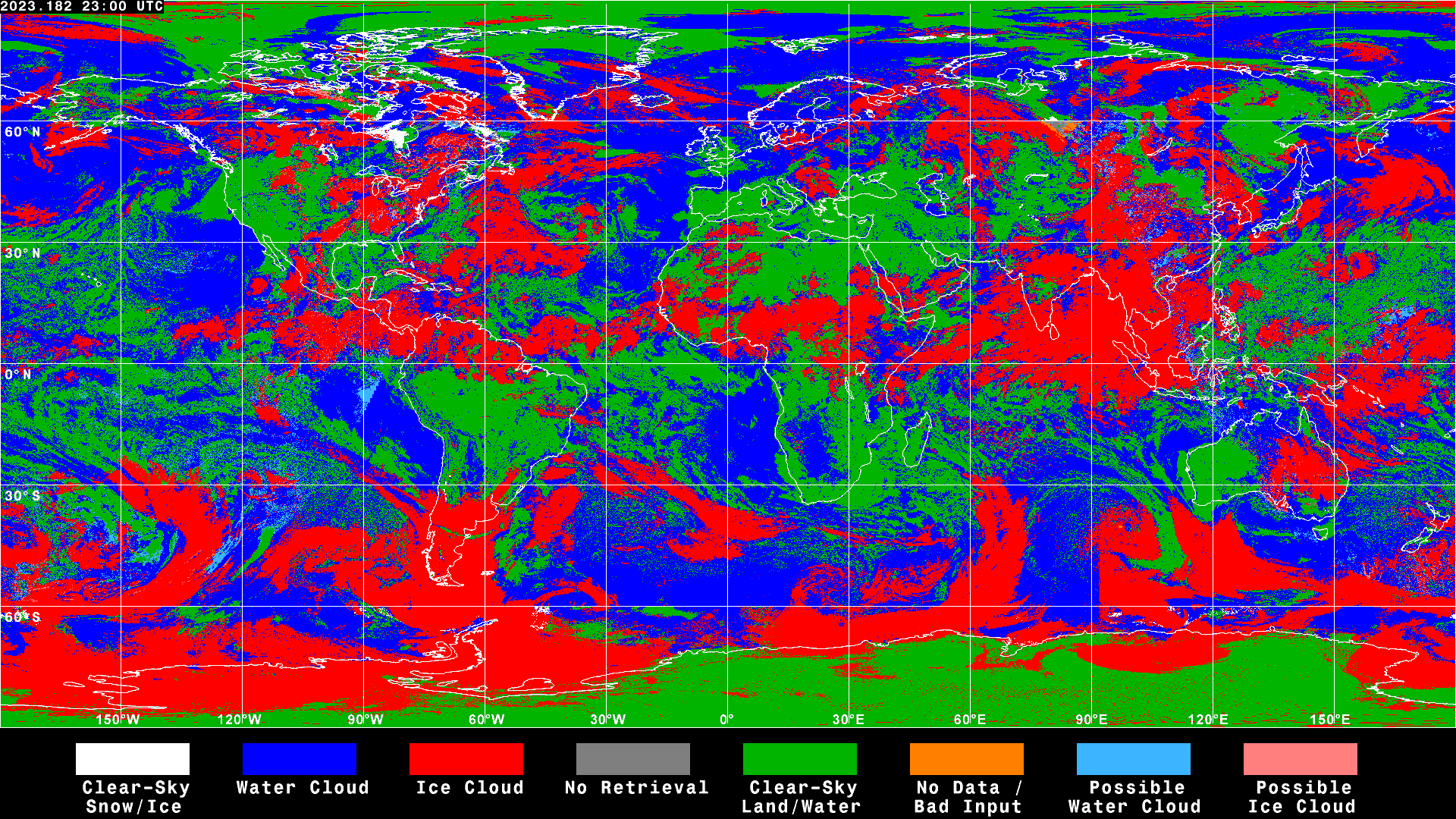
Cloud Phase: Indicates the radiatively-dominant thermodynamic phase determined and used
in the cloud optical property retrieval algorithm.
Does not indicate the presence of thin cirrus in some thin-ice overlapping water cloud
conditions.
Mixed phase clouds are not reported as a distinct class.
Cloud Optical Depth (OD): The amount of radiation attenuated by the cloud in a vertical
column reported for the visible channel (~0.65 um), derived at all times of day for consistency.
Depends on the cloud's physical thickness, concentration of cloud particles, size of cloud
particles.
OD=1 indicates the cloud had reduced the sun's visible wavelength energy by a factor of e which
means 63.2% of the sun's energy is blocked by the cloud.
Cloud Effective Water Radius: The cloud droplet effective radius in the top part of the
cloud.
Cloud Effective Ice Diameter: The cloud ice particle effective diameter in the top part
of the cloud.
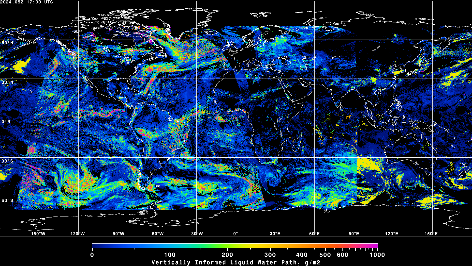
Cloud Liquid or Ice Water Path: The amount of cloud liquid water or ice water in a
vertical column above a unit surface area on the Earth.
Best Estimate/Vertically-Informed Water Path:
Satellite water paths that have been modified for optically-thick (OD>10) clouds with glaciated
tops assuming a single layer containing ice overlapping liquid cloud hydrometeors.
For these clouds, simultaneous estimates of LWP and IWP for a given pixel are derived with
parameterizations that account for cloud vertical structure based on the fusion of
visible/near-infrared satellite information with data from cloud models, microwave remote
sensors, CloudSat, and CALIPSO.
Aircraft Icing: Indicates the potential for ice buildup on aircraft in flight due to
supercooled cloud drops.
Cloud Effective Height/Pressure:
The effective height (or pressure level) is typically not far below actual cloud top and refers
to the height where the satellite infrared brightness temperature matches the model sounding
temperature.
For optically thin ice clouds, this level can be well inside or under the cloud and is adjusted
upward.
Broadband SW Albedo: The amount of radiant energy leaving the Earth at top of atmosphere
in the shortwave spectrum, expressed as a percentage of the incoming, derived from narrowband
satellite channel data.
Broadband LW Flux: The amount of radiant energy leaving the Earth at top of atmosphere in
the longwave spectrum, derived from narrowband satellite channel data.
Technical References
Minnis, P., et al., 2008: Near-real time cloud retrievals from operational and research
meteorological satellites. Proc. SPIE Europe Remote Sens. 2008, Cardiff, Wales, ID, 15-18 September,
7107, No. 2, 8pp. http://satcorps.larc.nasa.gov/site/doc-library/99-Minnis.etal.SPIE.abs.08.pdf
Minnis, P. et al., "CERES Edition-2 Cloud Property Retrievals Using TRMM VIRS and Terra and Aqua
MODIS Data--Part I: Algorithms," in IEEE Transactions on Geoscience and Remote Sensing, vol. 49, no.
11, pp. 4374-4400, Nov. 2011, doi: 10.1109/TGRS.2011.2144601.
Minnis, P. et al., "CERES MODIS Cloud Product Retrievals for Edition 4--Part I: Algorithm Changes,"
in IEEE Transactions on Geoscience and Remote Sensing, vol. 59, no. 4, pp. 2744-2780, April 2021,
doi: 10.1109/TGRS.2020.3008866.
Smith, W. L., P. Minnis, C. Fleeger, D. Spangenberg, R. Palikonda, L. Nguyen, 2012: Determining the
Flight Icing Threat to Aircraft with Single-Layer Cloud Parameters Derived from Operational
Satellite Data. J. Appl. Meteor. Climatol., 51, 1794-1810,
/icing/pub/journal/Smith.etal.JAMC.12.pdf
Smith Jr., 2014, PhD Dissertation, University of Wisconsin-Madison,
/icing/pub/WLS-Dissertation.pdf